Featured on BBC: GEOG and NASA Work Together to Measure Forest Disturbance After Hurricanes
GEOG and NASA Work Together to Measure Forest Disturbance After Hurricanes
Mangroves are often the first natural line of defense against the intense winds and storm surge during hurricanes. As the hurricane comes ashore, winds are slowed because of the drag across the tall dense mangrove forest canopy and storm and the wave energy is dissipated by the intricate network of stems and prop roots. Dr. David Lagomasino (Assistant Research Professor) is working with NASA (Drs. Lola Fatoyinbo, Bruce Cook, Douglas Morton) and research institutions in South Florida to measure the changes in forest structure following Hurricane Irma.
Hurricane Irma made landfall in the Florida Keys as a category 4 hurricane on September 10th and continued northward making landfall a second time on the mainland in Ft. Myers before continuing over the Florida peninsula. The hurricane generated a 3 meter storm surge accompanied by 110 mph winds along the southwest coast of Florida which houses the largest expanse of mangrove forests in the Caribbean.
Having the mangrove forests along the coast can help to reduce surface winds and attenuate wave energy by over 50%. If mangroves did not exist around the world, there would be an estimated $82 billion dollars of expected damages per year and over 18 million more people affected by flooded. For the US only, there is an estimated $13 billion dollars per year in development and infrastructure that are protected by mangrove forests.
The infrequent, but regular, impacts from catastrophic storms, like Hurricane Irma, are important events that impact the development and evolution of these coastal systems. But in addition to the impacts from catastrophic storms, the coastal wetlands in Florida (as well as in other tropical regions around the world) are also being squeezed by in all directions by human developments, urban expansion, and rising seas. The intensity of these interactions have acute and chronic impacts on both the natural and human landscapes along the coast. The shrinking of natural coastal habitats provide less protection against strong storms, while also allowing more salt water to move inland which ultimately effects the available freshwater resources that metropolitan areas in Florida rely so heavily on.
In March of 2017, as part of two research projects funded by NASA (PI – Lagomasino) and USDA (PI-Joseph Smoak, University of South Florida), Dr. Lagomasino coordinated an extensive airborne campaign to fly over South Florida using a unique airborne imaging package created at NASA Goddard Space Flight Center: G-LiHT (Goddard’s Lidar, Hyperspectral and Thermal). G-LiHT collected data over 1,300 km2 of wetlands (mangroves and marshes). Through the close coordination with NASA, Florida International University, University of South Florida, Florida Fish and Wildlife, USGS, Everglades National Park, and the US Forest Service the airborne campaign capitalized on a vast network of field sites that have collected long-term data for the past two to three decades. The two research projects have the objective monitoring the vulnerability and resilience of the coastal wetlands, and modeling the future of carbon and ecosystems changes as mangrove encroach into freshwater wetlands.
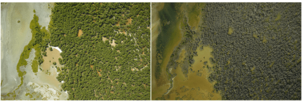
The unique suite of remote sensing data collected five months before Hurricane Irma provided amazing and unprecedented observations of the Florida coast. After the hurricane, Dr. Lagomasino (UMD) and Drs. Fatoyinbo, Cook, and Morton (NASA) saw a great opportunity to organize a follow-up flight and field campaign to assess the damages along the areas that were collected in March 2017. Through a NASA Rapid Grant (PI – Fatoyinbo), G-LiHT was able to fly again over Florida in December 2017 followed by field visits in January 2018. The team is still analyzing the XXX terabytes of imagery that were collected, but the preliminary estimates show that 3 months after the hurricane that %40-50 of the mangrove forests were covered with new canopy gaps. In addition, the forest volume was reduced by %10-20. Though these impacts are not that different from previous estimates of damage following Hurricane Wilma (2005) and Hurricane Andrew (1992), it is the large size of the impacted area that distinguishes this storm from its recent predecessors.
In addition, the airborne data the research team has also collected multiple ground-based lidar and stereo data that is being used to render the 3D structure of the forest below the canopy. A terrestrial laser scanner designed and built by the University of Massachusetts – Boston, and a stereo camera designed by Universities Space Research Association were used to collect the below canopy structure. The high-resolution 3D information will be used to model the impact of the hurricane in terms of fallen trees and broken trunks. Working closely with collaborators at FIU, the 3D data will help to improve biomass and storm surge modeling for coastal regions.
It is expected that most of the mangrove forest will recover, but it could take up to a decade or more for it reach a productivity that equals the pre-storm conditions. However, in subsequent field visits by Dr. Lagomasino and South Florida collaborators, several large patches of mangrove forests are drawing concern because there are few signs of a healthy recovery. It is some of these more stressed areas that may undergo a reorganization that ultimately transitions these forested ecosystem to open water. The unique team of researchers from the University of Maryland, NASA, and South Florida will continue to monitor the recovery after the storms and identify the landscape and vegetation patterns that drive the long-term resilience of coastal wetlands.
Watch the featured BBC segment here!
Published on Mon, 10/08/2018 - 09:58


