Bridging Science-Policy Gap for UNFCCC
Scientists at the Department of Geographical Sciences (UMD GEOG) will be working toward the uptake of space-based forest carbon maps to inform the Global Stocktake of United Nations Framework Convention on Climate Change (UNFCCC).
In a recently awarded NASA Carbon Monitoring System (CMS) three-year grant, Laura Duncanson (Principle Investigator, PI) and Neha Hunka (Science PI) will guide nations of the world on the operational use of carbon maps, modeled from data acquired from space, for policy reporting.
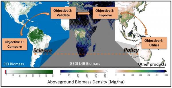
The proposed research is positioned to fill a fundamental gap in science and policy; the use of space-based carbon maps, such as those produced by the GEDI mission, to inform national and global policy is nearly non-existent as of 2023. In the awarded NASA CMS grant, researchers will compare carbon maps published by various space agencies and institutions, validate them using robust methods, test a suite of options to improve the maps with ground and airborne data, and co-develop practical tools to facilitate the uptake of maps by nations. The overarching goal is to support the formal incorporation of space-based carbon estimates to inform the Global Stocktake in 2025/26.
The research is supported by the NASA-ESA Multi-mission Algorithm and Analysis Platform (MAAP), based on open-science policies with the codes publicly released during the course of the project. The outcomes are expected to set the stage for maps from future missions, such as NASA-ISRO’s Synthetic Aperture Radar (NISAR) and the European Space Agency’s BIOMASS mission, to be seamlessly used for the collective global ambition of reducing forest carbon emissions.
Published on Tue, 06/06/2023 - 23:18


